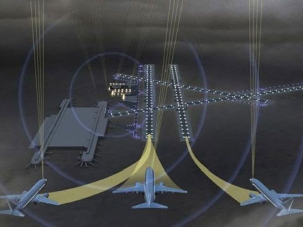
“Today’s airspace is crowded and on track to be even more crowded in the next 10 years. Airlines and airports need a more efficient and modern system to handle the influx of planes during approach and landing, specifically when the weather gets bad and pilots are operating in CAT III conditions. Honeywell has invented and tested a precision landing system that will not only alleviate crowded approaches and landings at airports, but will also give pilots the ability to land when they can’t see the runway, keeping airports and flights running efficiently,” said Bob Smith, Chief Technology Officer, Honeywell Aerospace.
Using Honeywell’s SmartPath Ground-Based Augmentation System (GBAS), Boeing used its ecoDemonstrator 787, a flight test airplane that in 2014 served to assess more than 25 technologies to reduce aviation’s environmental footprint, to complete 12 CAT III approaches and landings at Boeing’s test facility in Moses Lake, Washington. The aircraft also used Honeywell’s Integrated Navigation Receiver (INR), a navigation receiver that integrates the instrument landing signal, VHF omnidirectional range marker beacon and GBAS landing system navigation signals into a compact and more efficient unit.
To successfully complete the CAT III approaches, which involve performing landings automatically in difficult conditions including fog, clouds, rain or other weather phenomena, Honeywell upgraded the software of the 787 INR and SLS-4000 SmartPath GBAS to support the additional CAT III monitoring and availability requirements.
Honeywell has provided next-generation navigation technology to airports and airlines for decades. Its SmartPath precision landing system provides airports and airlines with a cost-effective solution that enables increased airport capacity, decreased air traffic noise, reduced weather-related delays and reduced operating costs. SmartPath accomplishes this by using signals from the Global Positioning System to provide aircraft operators with a very precise, digital navigation signal for precision approaches and landings.
SmartPath is currently being used with revenue-generating flights and was designed to be upgradable to support CAT III landings and approaches.
As well, Honeywell is continuing to implement these new technologies into its airborne navigation products such as the Integrated Multi-Mode Receiver, with the ability to upgrade via software updates.

