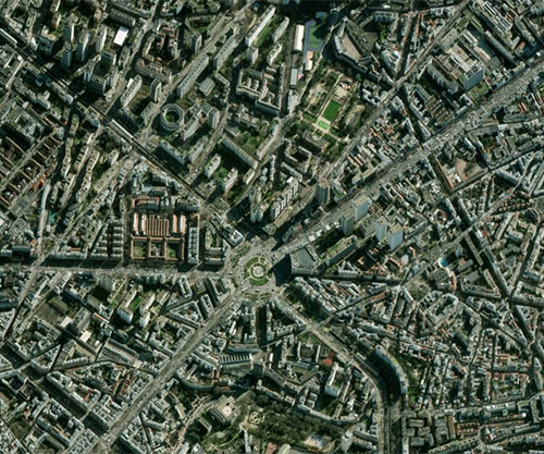





Vantor, the leading provider of unified spatial intelligence from space to ground, announced that the company and Esri have extended their long-term partnership through a new, multi-year contract. Through this multi-million dollar agreement, Vantor will deliver updated, high-resolution Vivid™ Mosaic imagery basemaps on a quarterly basis, giving Esri’s ArcGIS users the ability to interact with maps that are updated at the pace of change.
Vivid Mosaic will continue to be available as part of Esri’s ArcGIS Living Atlas of the World, a collection of authoritative geographic information layers used across ArcGIS. Esri subscribed to Vivid Mosaics with quarterly access to refreshed coverage.
Vantor determines the areas to refresh using AI-powered change detection capabilities that identify where meaningful changes to buildings, roads, and other map-relevant features are occurring, helping prioritize updates where maps may be falling behind the real world. High-demand and urban areas will be delivered at 30 cm resolution, giving ArcGIS users access to detailed, current imagery where the pace of change is highest.
“Esri customers depend on accurate, current basemaps to understand change, build applications, and make better decisions,” said Jack Dangermond, President of Esri. “Our decades-long partnership with Vantor helps ensure ArcGIS users continue to have access to the high-resolution satellite imagery they have come to rely on and trust for mapping, analysis, and visualization across the ArcGIS ecosystem.”
The renewal continues a more than 25-year partnership between Vantor and Esri, with Vantor serving as Esri’s single largest provider of satellite imagery.
Vivid Mosaic in ArcGIS Living Atlas of the World enables use cases such as:
- Civil governments keep city maps updated to enable ongoing improvements in traffic flow, evaluate development proposals, and document neighborhood changes.
- Researchers track melting ice, greenhouse gases, land cover, watersheds, and more to help enforce climate action, monitor natural resources, and plan conservation projects.
- Businesses conduct market analysis to evaluate a potential retail location, determine market coverage or saturation, and plan service territories.
“Vivid Mosaic gives ArcGIS users access to a high-resolution spatial foundation that is refreshed based on real-world change,” said Dan Smoot, CEO of Vantor. “By delivering current, accurate imagery through ArcGIS Living Atlas of the World, we’re helping Esri users build maps, design applications, and extract insights from a basemap they can trust.”
Vivid Mosaic is part of Vantor’s dynamic foundation product portfolio, which includes 2D imagery basemaps, 3D terrain data, and 2D/3D vector features designed to serve as a trusted spatial foundation for mapping applications, intelligence systems, and operational platforms.
Esri, the global market leader in geographic information system (GIS) software, location intelligence, and mapping, helps customers unlock the full potential of data to improve operational and business results.
Founded in 1969 in Redlands, California, USA, Esri software is deployed in hundreds of thousands of organizations globally, including Fortune 500 companies, government agencies, nonprofit institutions, and universities. Esri has regional offices, international distributors, and partners providing local support in over 100 countries on six continents.
Vantor is forging the new frontier of spatial intelligence to unlock a more autonomous, interoperable world. The company gives decision makers and operators the power to build a unified intelligence picture, delivering the clarity they need to navigate what’s happening now and shape what’s coming next.
Vantor fuses data from the world’s most capable imaging satellites with real-time sensor feeds from space, air, and ground to create an AI-ready digital twin of Earth.
Vantor’s spatial intelligence platform automates every part of the cycle - from tasking to collection to production - to update and analyze this foundation at the pace of change. Its products drive deeper mission-critical insights and connect the next generation of autonomous systems across the defense, intelligence, and commercial landscape.